Dataset of above ground biomass in Sanjiangyuan region (2000, 2010, 2015 )
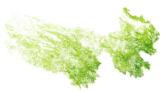
The method of aboveground biomass of grassland is zonal classification model. The data years were 2000, 2010 and 2015, and the fresh vegetation weight was based on the first ten days of August. Above-ground biomass is defined as the total amount of organic matter of vegetation living above the ground in a unit area. Unit: g/m². This data set is calculated from a statistical model based on the MODIS vegetation index by the Institute of Remote Sensing and Digital Earth, Chinese Academy of Sciences. The spatial resolution is 250 m x 250 m. The data set is an important data source for vegetation monitoring in Three River Source National Park. Projection information: Albers isoconic projection Central meridian: 105 degrees First secant: 25 degrees First secant: 47 degrees West deviation of coordinates: 4000000 meters
To respect the intellectual property rights, protect the rights of data authors, expand services of the data center, and evaluate the application potential of data, data users should clearly indicate the source of the data and the author of the data in the research results generated by using the data (including published papers, articles, data products, and unpublished research reports, data products and other results). For re-posting (second or multiple releases) data, the author must also indicate the source of the original data.
三江源国家公园星空地一体化生态监测及数据平台(SJYNP)
Sign In to add comments

三江源国家公园星空地一体化生态监测数据平台 © 2018-2021 陇ICP备05000491号 | All Rights Reserved
|  京公网安备11010502040845号
数据中心技术支持: 数云软件
