The boundaries of the source regions in Sanjiangyuan region (2018)
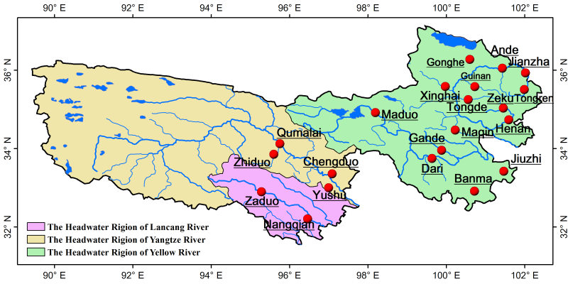
The data set contains the boundaries of the three source regions of the Yellow River, the Yangtze River and the Lancang River, the boundary of the whole Sanjiangyuan region and the boundaries of the counties within the basin. The observation projects include the boundaries of the three source regions of the Yellow River, the Yangtze River and the Lancang River, the boundary of the whole Sanjiangyuan region and the boundaries of the counties within the basin.
Yanqiang Wei. The boundary of the source regions of Yangtze River, Lancang River and Yellow River. Space-Air-Field Integrated Eco-Monitoring and Data Infrastructure of the Three-River-Source National Park.2018
To respect the intellectual property rights, protect the rights of data authors, expand services of the data center, and evaluate the application potential of data, data users should clearly indicate the source of the data and the author of the data in the research results generated by using the data (including published papers, articles, data products, and unpublished research reports, data products and other results). For re-posting (second or multiple releases) data, the author must also indicate the source of the original data.
1.Drone photoes of Qumalai alpine meadow plot (2018)
2.Drone orthophoto image and DSM of Qumalai alpine meadow plot (2018)
3.Drone orthophoto image and DSM of Qinghai Hoh Xil plot (2018)
4.Drone orthophoto image and DSM of Qumalai wetland plot (2018)
5.Aerial Drone photos of Hoh Xil plot (2018)
6.Rare animals survey dataset for the Three-River Headwater Region (2016-2017)
No record
No record
Sign In to add comments
Resource Provider: WEI Yanqiang Establishing Developing and Applying of the Space-Air-Field Integrated Eco-Monitoring and Data Infrastructure of the Three-River-Source National Park

三江源国家公园星空地一体化生态监测数据平台 © 2018-2021 陇ICP备05000491号 | All Rights Reserved
|  京公网安备11010502040845号
数据中心技术支持: 数云软件
