Spot vegetation NDVI dataset for Sanjiangyuan (1998-2013)
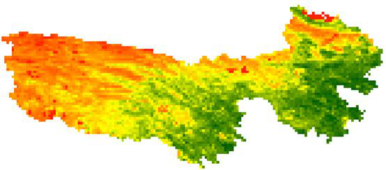
The data set is extracted from the NDVI data of long time series acquired by VEGETATION sensor on SPOT satellite. The time range of the data set is from May 1998 to 2013. In order to remove the noise in NDVI data, the maximum synthesis is carried out. A NDVI image is synthesized every 10 days. The data set is cut out from the global data set, so as to carry out the research and analysis of the source areas of the three rivers separately. The data format of this data set is geotiff, spatial resolution is 1 km, temporal resolution is 10 days, time range: May 1998 to December 2013.
In .geotiff format, can be read and edited in GIS or RS software.
[1] Deronde, B., Debruyn, W., Gontier, E., Goor, E., Jacobs, T., Verbeiren, S., & Vereecken, J. (2014). 15 years of processing and dissemination of SPOT-VEGETATION products. International Journal of Remote Sensing, 35(7), 2402–2420. (查看)
To respect the intellectual property rights, protect the rights of data authors, expand services of the data center, and evaluate the application potential of data, data users should clearly indicate the source of the data and the author of the data in the research results generated by using the data (including published papers, articles, data products, and unpublished research reports, data products and other results). For re-posting (second or multiple releases) data, the author must also indicate the source of the original data.
三江源国家公园星空地一体化生态监测及数据平台(SJYNP)
1.Drone photoes of Qumalai alpine meadow plot (2018)
2.Drone orthophoto image and DSM of Qumalai alpine meadow plot (2018)
3.Drone orthophoto image and DSM of Qinghai Hoh Xil plot (2018)
4.Drone orthophoto image and DSM of Qumalai wetland plot (2018)
5.Aerial Drone photos of Hoh Xil plot (2018)
6.Rare animals survey dataset for the Three-River Headwater Region (2016-2017)
No record
No record
Sign In to add comments
Resource Provider: Image Processing Centre for SPOT-VGT

三江源国家公园星空地一体化生态监测数据平台 © 2018-2021 陇ICP备05000491号 | All Rights Reserved
|  京公网安备11010502040845号
数据中心技术支持: 数云软件
