Time series DEM of glacier surface in the source area of the Yangtze River and Selin Co region (1976-2017)
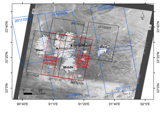
Geladandong region is an important and typical source region of great rivers and lakes in the Qinghai Tibet Plateau. This data set provides DEM covering glaciers in the source region of the Yangtze River and Selin Co with different time scales and resolutions to calculate the seasonal and decadal changes of glacier surface elevation in the source region. This data set includes seven 5-meter resolution TanDEM-X data from July 2016 to 2017, which can be used to calculate the seasonal change of glacier surface elevation; it includes one KH-9 DEM with a resolution of 30m in 1976, five TanDEM-X with a resolution of 30m in 2011, one TanDEM-X in 2014 and three TanDEM-X in 2017 with a resolution of 30m. The data can be used to calculate the change of glacier surface elevation during 1976-2000, 2000-20112011-2017. At the same time, Landsat ETM data are used to extract the glacier outline in 1976and we divide it according to the RGI6.0; The right figure shows the spatial and temporal coverage information of the data set, and the base figure is the orthophoto corrected kh-9 image.
The data file is named according to the sensor plus date information. Where, tdx refers to TanDEM-X cossc data, kh9 refers to hexagon kh-9, ETM refers to Landsat ETM, and the date is in yyyymmdd format. The data is in GeoTIFF and ShapeFile format and can be opened in ArcGIS or QGIS and other GIS software. DEM's projection is WGS_ 1984_ UTM_ Zone_ 46n, the glacier contour is projected as Albert conical equal area
[1] Chen, W., Yao, T., Zhang, G., Li, S., & Zheng, G. (2021). Accelerated glacier mass loss in the largest river and lake source regions of the Tibetan Plateau and its links with local water balance over 1976–2017. Journal of Glaciology 1–15. https://doi.org/10.1017/jog.2021.9. (查看)
To respect the intellectual property rights, protect the rights of data authors, expand services of the data center, and evaluate the application potential of data, data users should clearly indicate the source of the data and the author of the data in the research results generated by using the data (including published papers, articles, data products, and unpublished research reports, data products and other results). For re-posting (second or multiple releases) data, the author must also indicate the source of the original data.
第二次青藏高原综合科学考察研究
祁连山“山水林田湖草”系统的综合监测与评估(XDA20100101)
国家自然科学基金
No record
No record
No record
Sign In to add comments

三江源国家公园星空地一体化生态监测数据平台 © 2018-2021 陇ICP备05000491号 | All Rights Reserved
|  京公网安备11010502040845号
数据中心技术支持: 数云软件
