
新闻动态
NEWS

Integrated Hydrometeorological – snow – frozen Ground Observations in the Alpine Region of the Heihe River Basin in China Published
An article entitled as "Integrated hydrometeorological - snow - frozen ground observations in the alpine region of the Heihe River Basin, China" was recently published in Earth System Science Data by CHE Tao (first author), Northwest Institute of Eco-Environment and Resources of China Academy of Sciences, and LI Xin (correspondent author), Institute of Tibetan Plateau Research of Chinese Academy of Sciences, and other collaborators. The relevant 80 datasets on hydrothermal flux observations, hydrometeorological observations and integrated observations of surface processes in the alpine region of the Heihe River basin was released at the National Tibetan Plateau Data Center (http://data.tpdc.ac.cn/) and is available for free download.
The alpine mountains are an important source of water on which the mid and lower reaches of the ecosystem depend. In recent years, climate change and human activities and other perturbations may disturb hydrological processes and eco-functions, creating the need for next-generation observational and modeling approaches to advance a predictive understanding of such processes in the alpine region. Currently, most observatories are based on small-scale, single geographic element observations. An integrated, distributed and multiscale observation network is urgently needed to promote hydrological processes and remote sensing research in alpine regions.
In response to this scientific question, the research team established a multiscale integrated ecological and hydrological observation network for the Heihe River Basin, which covers several geographical elements of glaciers, snow, tundra, alpine meadows, forests, irrigated crops, riparian ecosystems and deserts. On this basis, an integrated, distributed and multiscale ground observation network of the upper Heibe River was integrated and a comprehensive dataset of long-term hydrometeorological, snow cover and frozen ground data for the alpine mountains was established.
The datasets consist mainly of seven automated meteorological stations, two superstations for snow cover and frozen ground observations. The observed meteorological variables include wind (speed and direction), air temperature, humidity, infrared temperature, air pressure, four-component radiation, and precipitation. The snow properties such as snow depth, snow water equivalent (measured by GammaMONitor), snow albedo, and snow surface and blowing (drifting) snow flux (measured by FlowCapt), etc. observed by the snow superstation can well capture the snow accumulation and depletion process. At the same time, soil temperature and moisture profiles were intensively measured from the frozen ground superstation are used to obtain the freeze-thaw process of the soil.
The release of the datasets could support scientific research for alpine hydrology, cryosphere and science, such as providing accurate and effective forcing data for hydrological models, evaluating the accuracy and applicability of remote sensing products and studying the mechanisms of key hydro-ecological processes in watersheds.
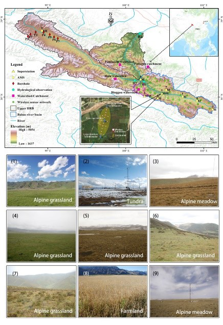
The integrated hydrometeorological-snow-frozen ground observation network in the upper reaches of the Heihe River Basin in China.
The paper information:
,Che T, Li X, Liu SM, Li HY, Xu ZW, Tan JL, Zhang Y, Ren ZG, Xiao L, Deng J, Jin R, Ma MG, Wang J, Yang XF. Integrated hydrometeorological, snow and frozen-ground observations in the alpine region of the Heihe River Basin, China. Earth System Science Data, 2019, 11(3): 1483-1499. ,https://doi.org/10.5194/essd-2019-11.

 京公网安备11010502040845号