Dataset of soil erosion intensity with 300m resoluton in Tibetan Plateau (1992, 2005, 2015)
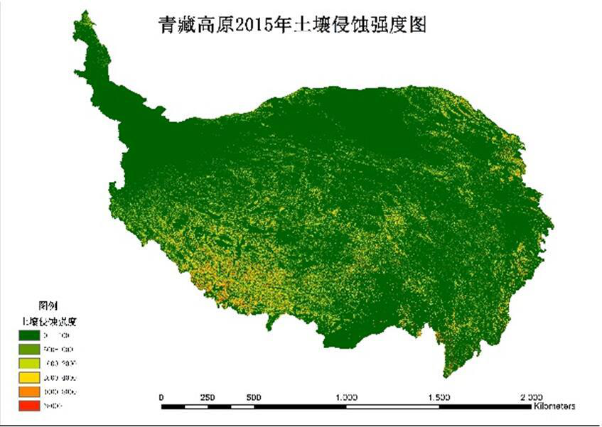
1) The data content includes three stages of soil erosion intensity in Qinghai-Tibet Plateau in 1992, 2005 and 2015m the grid resolution is 300m.2) The data of soil erosion intensity are obtained by using the Chinese soil erosion prediction model (CSLE). The formula of soil erosion prediction model includes rainfall erosivity factor, soil erodibility factor, slope length factor, slope factor, vegetation cover and biological measure factor, engineering measure factor and tillage measure factor. Rainfall erodibility factors are calculated from the daily rainfall data by the US Climate Prdiction Center (CPC); soil erodibility factors, engineering measures factors and tillage measures factors are obtained from the first water conservancy census data; slope length factors and slope factors are obtained by resampling after calculating 30 m elevation data; vegetation coverage and biological measures factors are obtained by combining fractional vegetation cover with land use data and rainfall erodibility proportionometer. The fractional vegetation cover is calculated by MODIS vegetation index products through pixel dichotomy. 3) Compared with the data of soil erosion intensity in the same region in the same year, there is no significant difference and the data quality is good.4) the data of soil erosion intensity is of great significance for studying the present situation of soil erosion in Pan third polar 65 countries and better carrying out the development policy of the area along the way.
XDA200402022-CSLE_QZGY1992A.tif represents the soil erosion intensity data of Qinghai-Tibet Plateau in 1992, of which, XDA20040202 is the subproject number, the 2 is the group number of the subproject, QZGY represents Qinghai-Tibet Plateau, and 1992 represents the year, A represents the soil erosion modulus. Geotiff format, can be opened and analysed in ArcGIS software.
To respect the intellectual property rights, protect the rights of data authors, expand services of the data center, and evaluate the application potential of data, data users should clearly indicate the source of the data and the author of the data in the research results generated by using the data (including published papers, articles, data products, and unpublished research reports, data products and other results). For re-posting (second or multiple releases) data, the author must also indicate the source of the original data.
泛第三极环境变化与绿色丝绸之路建设专项(XDA20000000)
No record
No record
No record
Sign In to add comments
Resource Provider: ZHANG Wenbo

三江源国家公园星空地一体化生态监测数据平台 © 2018-2021 陇ICP备05000491号 | All Rights Reserved
|  京公网安备11010502040845号
数据中心技术支持: 数云软件
