Simulation data of active layer thickness and ground temperature of permafrost in Qinghai Tibet Plateau (2000-2015, 2061-2080)
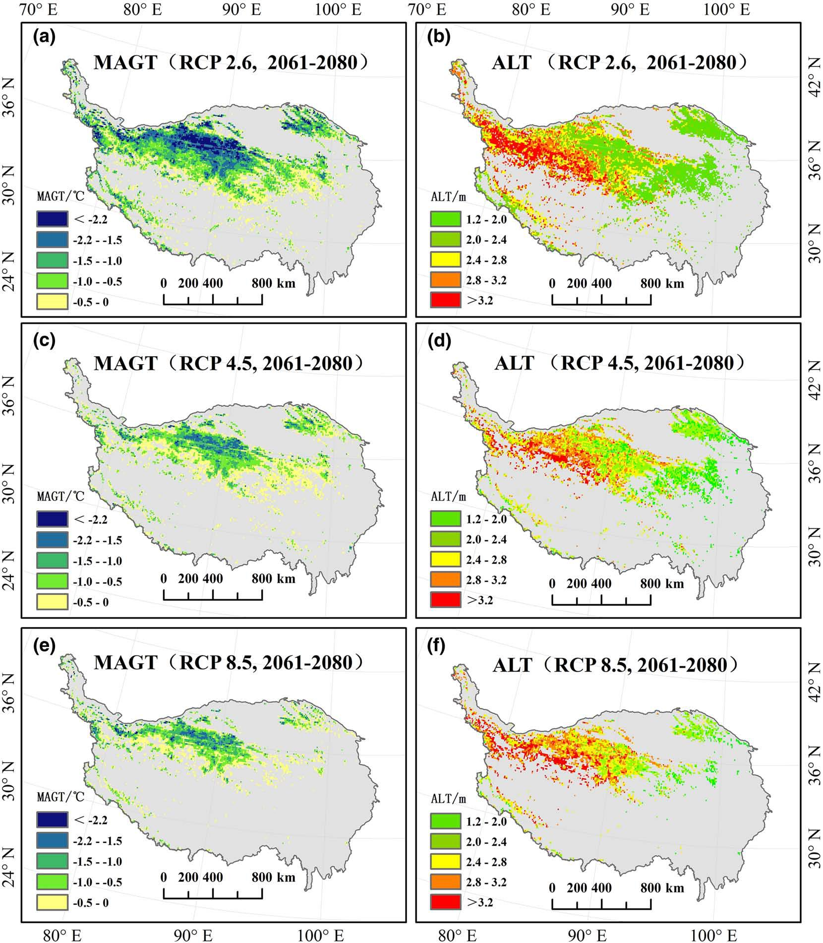
A comprehensive understanding of the permafrost changes in the Qinghai Tibet Plateau, including the changes of annual mean ground temperature (Magt) and active layer thickness (ALT), is of great significance to the implementation of the permafrost change project caused by climate change. Based on the CMFD reanalysis data from 2000 to 2015, meteorological observation data of China Meteorological Administration, 1 km digital elevation model, geo spatial environment prediction factors, glacier and ice lake data, drilling data and so on, this paper uses statistics and machine learning (ML) method to simulate the current changes of permafrost flux and magnetic flux in Qinghai Tibet Plateau The range data of mean ground temperature (Magt) and active layer thickness (ALT) from 2000 to 2015 and 2061 to 2080 under rcp2.6, rcp4.5 and rcp8.5 concentration scenarios were obtained, with the resolution of 0.1 * 0.1 degree. The simulation results show that the combination of statistics and ML method needs less parameters and input variables to simulate the thermal state of frozen soil, which can effectively understand the response of frozen soil on the Qinghai Tibet Plateau to climate change.
The data is stored in grid. TIF format, and the file is named after the simulation results of mean ground temperature (Magt) and active layer thickness (ALT) in different scenes, such as alt_ Rcp85.tif is the simulation data of the active layer thickness (ALT) of frozen soil in rcp8.5 scenario. It can be opened and read by ArcGIS, ENVI and other remote sensing software.
[1] Ni, J., Wu, T., Zhu, X., Hu, G., Zou,D., & Wu, X., et al. (2021). Simulation of the present and future projection of permafrost on the Qinghai-Tibet Plateau with statistical and machine learning models. Journal of Geophysical Research: Atmospheres,126, e2020JD033402. https://doi.org/10.1029/2020JD033402. (查看)
To respect the intellectual property rights, protect the rights of data authors, expand services of the data center, and evaluate the application potential of data, data users should clearly indicate the source of the data and the author of the data in the research results generated by using the data (including published papers, articles, data products, and unpublished research reports, data products and other results). For re-posting (second or multiple releases) data, the author must also indicate the source of the original data.
泛第三极环境变化与绿色丝绸之路建设专项(XDA20000000)
No record
No record
No record
Sign In to add comments

三江源国家公园星空地一体化生态监测数据平台 © 2018-2021 陇ICP备05000491号 | All Rights Reserved
|  京公网安备11010502040845号
数据中心技术支持: 数云软件
