Dataset of Soil Erosion (water) Intensity with 300m resoluton in Tibetan Plateau (1992, 2005, 2015)
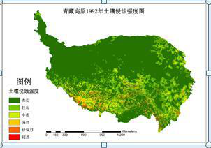
1)The data content includes three stages of soil erosion intensity in Qinghai-Tibet Plateau in 1992, 2005 and 2015, and the grid resolution is 300m. 2) China soil erosion prediction model (CSLE) was used to calculate the soil erosion amount of more than 4,000 investigation units on the Qinghai-Tibet Plateau. Soil erosion was interpolated according to land use on Qinghai-Tibet Plateau. According to the soil erosion classification standard, the soil erosion intensity map of Qinghai-Tibet Plateau was obtained. 3) By comparing the differences of three-stage soil erosion intensity data, it conforms to the actual change law and the data quality is good. 4) The data of soil erosion intensity are of great significance to the study of soil erosion in the Qinghai-Tibet Plateau and the sustainable development of local ecosystems. In the attribute table, "Value" represents the erosion intensity level, from 1 to 6, the value represents slight, mild, moderate, intense, extremely intense and severe. "BL" represents the percentage of echa erosion intensity in the total area.
XDA200402022-CSLE_QZGY1992(2005/2015)E.tif represents the soil erosion intensity data of Qinghai-Tibet Plateau in 1992(2005/2015), of which, XDA20040202 is the subproject number, following number "2" is the group number of the subproject, QZGY represents Qinghai-Tibet Plateau, 1992(2005/2015) represents the year, and E represents soil erosion intensity. Geotiff format, can be opened and analysed in ArcGIS software.
To respect the intellectual property rights, protect the rights of data authors, expand services of the data center, and evaluate the application potential of data, data users should clearly indicate the source of the data and the author of the data in the research results generated by using the data (including published papers, articles, data products, and unpublished research reports, data products and other results). For re-posting (second or multiple releases) data, the author must also indicate the source of the original data.
泛第三极环境变化与绿色丝绸之路建设专项(XDA20000000)
No record
No record
No record
Sign In to add comments
Resource Provider: ZHANG Wenbo

三江源国家公园星空地一体化生态监测数据平台 © 2018-2021 陇ICP备05000491号 | All Rights Reserved
|  京公网安备11010502040845号
数据中心技术支持: 数云软件
